


Mapping Jesus' Travels
These are some maps that have been created based upon The Urantia Book's part IV. The first one is tracing Jesus' travels to Rome and back, based upon Papers 130, 132, and 133.

Some of these places in Israel I had a chance to visit in 2010. Here are some of the images from that time.
"This youth of India [Ganid, Jesus' pupil for the journey] was much impressed with the temple of Augustus, situated upon an elevation and surmounted by a colossal statue of the Roman emperor. The second afternoon of their stay the three of them attended a performance in the enormous amphitheater which could seat twenty thousand persons, and that night they went to a Greek play at the theater. These were the first exhibitions of this sort Ganid had ever witnessed, and he asked Jesus many questions about them. On the morning of the third day they paid a formal visit to the governor’s palace, for Caesarea was the capital of Palestine and the residence of the Roman procurator." (UB 130:2.1)

Above: the statue of the Roman emperor; above right: the Roman amphitheater, refurbished for contemporary performances; right: Roman aqueduct still standing.
For more images of the areas that Jesus walked, see video in the link provided below.


Where Jesus Walked


More maps of the land of Jesus


Jerusalem of the 1st Century AD

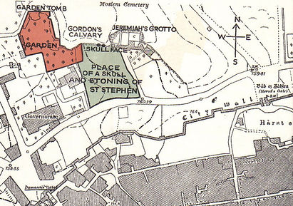


The Garden Tomb
Golgotha
The Garden Tomb
Golgotha
